4.2.300 Submittal Requirements.
A. An application for review under this chapter must include the following information, as deemed applicable by the Community and Economic Development Director based on the size, scale and complexity of the development.
1. Existing Site Conditions Map. At a minimum the existing site conditions map shall contain the following:
a. The applicant’s entire property and the surrounding property to a distance of 150 feet from the subject property. Existing aerial photos may be used. The property boundaries, dimensions and gross area shall be identified;
b. Topographic contour lines shown at one-foot intervals for slopes of 10 percent or less. For slopes greater than 10 percent, contour lines shall be shown at two-foot intervals. Slopes greater than 25 percent shall be identified;
c. The location and width of all public and private streets, drives, sidewalks, pathways, rights-of-way, and easements on the site and adjoining the site for a distance of 150 feet. Existing aerial photos may be used;
d. Potential natural hazard areas, including any areas identified as subject to a 100-year flood, areas subject to high water table, and areas mapped by the City, County, or State as having a potential for geologic hazards;
e. Resource areas, including wetlands on the City’s Local Wetlands Inventory, streams, surface mines, and wildlife habitat identified by the City or any natural resource regulatory agencies as requiring protection;
f. Features, including existing structures, pavement, large rock outcroppings, drainage ways, canals and ditches both on the site and adjoining the site for a distance of 150 feet. Existing aerial photos may be used;
g. The location, size and species of trees and other vegetation having a caliper (diameter) of six inches or greater at four feet above grade;
h. Locally or federally designated historic and cultural resources on the site and the adjacent parcels;
i. North arrow, scale, names and addresses of all persons listed as owners on the most recently recorded deed;
j. Name, address, email address and telephone number of project designer, engineer, surveyor, and/or planner, if applicable.
2. Proposed Site Plan. The site plan shall contain the following information (as applicable):
a. The proposed development site, including boundaries, dimensions, and gross area;
b. Existing site features, including trees, identified on the site analysis map, if any, which are proposed to be retained or modified by the proposed development;
c. The location and dimensions of all existing and proposed structures, utilities, pavement and other improvements on the site and adjacent to the site for a distance of 150 feet. Setback dimensions for all existing and proposed buildings shall be provided on the site plan;
d. The location and dimensions of all site circulation for vehicles, pedestrians and bicycles including entrances and exits to the site, loading and service areas;
e. The location and dimensions of all vehicle parking areas (show striping for parking stalls and wheel stops (if applicable) and bicycle facilities);
f. The location, type and height of exterior lighting fixtures;
g. Locations of bus stops and other public or private transportation facilities;
h. Loading and service areas for waste disposal, loading and delivery;
i. Outdoor recreation spaces, common areas, plazas, outdoor seating, street furniture, and similar improvements.
3. Deed Restrictions. The applicant shall submit copies of all existing and proposed restrictions or covenants.
4. Architectural Drawings. The Community and Economic Development Director may request architectural drawings showing one or all of the following:
a. Building elevations with building height and width dimensions;
b. Floor plans;
c. Building materials, colors and type;
d. The name, address and phone number of the architect or designer.
5. Preliminary Grading and Drainage Plan. A preliminary grading and drainage plan prepared by a registered professional engineer or registered landscape architect shall be required in conformance with BC Title 16, Grading, Excavation, and Stormwater Management. The preliminary grading plan shall show the location and extent to which grading will take place, indicating general changes to contour lines, slope ratios, slope stabilization proposals, and location and height of retaining walls, if proposed.
6. Surface Water Detention and Treatment Plan. A plan prepared by a registered professional engineer or registered landscape architect showing all drainage retention areas, catch basins, and storm piping prepared in accordance with BDC 3.4.500, Storm Drainage Improvements and BC Title 16, Grading, Excavation and Stormwater Management, shall be required.
7. Landscape Plan. A landscape plan must be submitted in compliance with BDC Chapter 3.2, Landscaping, Street Trees, Fences and Walls, and it must include the following (as applicable):
a. A planting schedule containing the location, size, and species of the existing and proposed plant materials (at time of planting);
b. Existing and proposed building and pavement outlines;
c. Irrigation plans, written soil specifications at time of planting, and anticipated plant installation time line;
d. The location of existing and proposed terraces, retaining walls, decks, patios, shelters, and play areas;
e. Existing and proposed abutting street right-of-way landscaping;
f. Landscape calculations pursuant to BDC 3.2.300(C), Landscape Area Standards, and a site plan clearly identifying the area included in the calculations;
g. Developments that opt to comply with the tree canopy requirement in BDC 3.3.300(D)(2)(a) must provide a tree canopy plan demonstrating compliance with BDC 3.2.300(E)(1)(b), Developments With More Than One-Half Acre of New Surface Parking Area;
h. Developments that opt to comply with the parking lot driveway and drive aisle tree requirements in BDC 3.3.300(D)(2)(b) must provide a site plan demonstrating compliance with BDC 3.2.300(E)(2), Parking Lot Driveway and Drive Aisles;
i. Other information as deemed appropriate by the Community and Economic Development Director. An arborist’s report may be required for sites with mature trees that are protected under BDC Chapter 3.2, Landscaping, Street Trees, Fences and Walls.
8. Sign Drawings. Depictions of proposed signs shall be in conformance with BC Chapter 9.50, Signs. A separate sign permit will be required for all signs.
9. Narrative. Letter or narrative report documenting compliance with the applicable approval criteria contained in BDC 4.2.500(D), Site Plan Review Approval Criteria.
10. Traffic Impact Study. A Traffic Impact Analysis shall be submitted if required by BDC Chapter 4.7, Transportation Analysis.
11. Water and Sewer Capacity Analyses. These analyses are provided by the City upon request and payment of fee, if required.
12. If the properties are not served by the City sewer system in accordance with BC Title 15, provide documentation from the Deschutes County Environmental Soils Division which indicates that the proposed development will be in compliance with all applicable requirements for sanitary septic systems when such systems exist on the properties affected by the development.
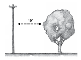
13. Coordination With Electric Utility Companies. For developments where the tree canopy at 15 years will be within 10 feet of an overhead powerline, transformer or underground electrical service, a letter or other written documentation from the local electric utility company must be submitted which indicates that the applicant has met with the company to discuss the tree canopy plan and coordination with pre-design, design, building and maintenance phases.
14. Additional Information. The Community and Economic Development Director may require, at the applicant’s expense, studies, reports or exhibits prepared by qualified professionals to address specific site features or concerns. [Ord. NS-2488, 2023; Ord. NS-2445, 2022; Ord. NS-2361, 2020; Ord. NS-2251, 2015]