Article III. Dean Swift Refinement Plan Development Standards Revised
2.7.400 Dean Swift Refinement Plan Development Standards.
A. Purpose. The Dean Swift Refinement Plan overlay is intended to implement the Dean Swift Neighborhood Plan concepts and to create special overlay zoning standards for the residential and mixed-use designations within the refinement plan area. The overlay standards will:
•Provide a variety of housing types.
•Locate higher densities near commercial corridors and services or along transit corridors.
•Create opportunities for neighborhood-oriented services.
•Ensure compatibility within the neighborhood and surrounding area.
•Improve the local street grid for automobiles and pedestrian benefit.
•Create a livable neighborhood for all ages.
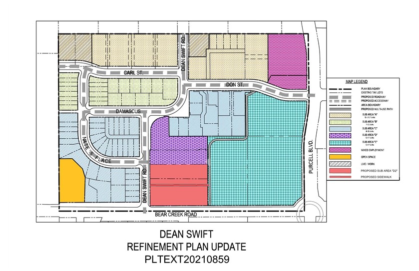
The Dean Swift Refinement Plan area is approximately 29 acres in size. The area is intended to remain primarily residential in character and use. Through the refinement plan public process, approximately 2.05 acres of the total land area were identified for development as Mixed Employment. In addition, residential sub-areas within the neighborhood have been identified to create a transition between the commercial high use areas along Highway 20 and the established residential uses to the south. The sub-areas are shown on the attached map.
B. Use Standards. The special standards of the Dean Swift Refinement Plan area supersede the standards of the underlying zone. Where no special standards are provided, the applicable standards of the underlying zone apply.
1. Modified RM Residential Overlay.
a. Sub-area “A” is located along the north side of Carl and Don Streets and south of the Highway 20 Commercial District. Sub-area “A” does not extend to Purcell Boulevard. The purpose of this area is to provide a transition between the commercial development to the north along Highway 20 and the residential neighborhood. The development characteristics of sub-area “A” are as follows:
•The residential density range is 10 to 21 units per gross acre.
•The maximum building height is 40 feet.
•Lot coverage is 50 percent except townhomes, duplexes, triplexes, quadplexes, single-room occupancies and multi-units is 60 percent.
•Two locations within the sub-area have been designated for “live/work” development. This allows low impact commercial use on the ground floor of a building; provided, that an equal or greater area of residential use is provided on the upper floors.
b. Sub-area “B” is located between Carl Street and Damascus Street, west of Dean Swift Road. The purpose of sub-area “B” is to provide a diversity of housing types in close proximity to goods and services. The development characteristics of sub-area “B” are as follows:
•The residential density range for this sub-area is seven to 12 units per gross acre.
c. Sub-area “C” is located north of Bear Creek Road, south of Damascus Street along the west side of Dean Swift Road. A second area encompasses an existing single-unit development lying south of Don Street and west of the north/south extension of “C” Street. This area represents a more traditional residential neighborhood. The development characteristics of sub-area “C” are as follows:
•The residential density range for this sub-area is six to 10 units per gross acre.
d. Sub-area “D” is located north of Bear Creek Road between Dean Swift Road and the north/south extension of “C” street, and is comprised of two sections: D1 (all lands north of current Tax Lot 171234DC01603), and D2 (all lands south of existing Tax Lot 171234DC01600). The development characteristics of sub-area “D” are as follows:
i. D1.
•The residential density range for this sub-area is 12 units to 17 units per acre.
•The maximum building height is 40 feet.
ii. D2.
•The maximum building height is 40 feet.
e. Sub-area “E” is located north of Bear Creek Road and west of Purcell Boulevard. The development characteristics of sub-area “E” are as follows:
•The maximum building height is 40 feet.
•The maximum lot coverage is 45 percent.
f. Lot Requirements. The lot requirements for the RM Zone as described in BDC Chapter 2.1 shall be observed unless specifically addressed by each sub-area or as indicated below.
i. The minimum front yard setbacks within all sub-areas shall be five feet for buildings, except garages and carports shall be set back 18 feet. Corner lots will need to observe the clear vision setbacks in addition to the overlay setbacks. Uncovered porches and stoops may encroach into the setback a maximum of two feet.
ii. Side and rear yard setbacks do not increase based on building height.
iii. Vehicular access shall be from an alley where provided.
2. Modified Mixed Employment Overlay.
a. The permitted and conditional uses in the Mixed Employment Zone are very diverse. Some of the uses in the ME Zone could adversely impact the residential character of the Dean Swift neighborhood, thereby obstructing the intent and purpose of the overlay. For this reason, the overlay zone will restrict the permitted and conditional uses for this area. ME uses within the Dean Swift Refinement Overlay will be limited to the following permitted and conditional uses.
b. Permitted Uses.
i. Service commercial and retail uses, excluding drive-through service.
ii. Professional office, excluding medical uses.
iii. Residential housing located above or behind a permitted or conditional use.
iv. Auto-related/auto-dependent uses when contiguous to a Commercial Zone.
v. Shelters, see BDC 3.6.600.
c. Conditional Uses.
i. Commercial day nursery or day care facility that is not part of a service for employees of a permitted or conditional use.
d. Service commercial, retail or office buildings greater than 5,000 square feet of gross floor area shall provide residential dwelling units above or behind the use at a ratio of two dwelling units per 5,000 square feet.
C. Neighborhood Open Space. An area of land located in the southwest corner of the Plan area with frontage along Bear Creek Road has been designated as open space as shown on the Refinement Plan map. A natural rock outcrop elevates this area. The area would be difficult to develop for residential purposes and shall remain as natural open space unless it is combined with the contiguous property to the west for public use. The development potential for the preserved area may be transferred to the balance of the parcel for development.
D. Street and Pedestrian Standards. All streets within the refinement area are designated as local streets. Bear Creek Road, designated as a minor arterial, and Purcell Boulevard, designated as a major collector, border the refinement area. All streets and pedestrian facilities shall be consistent with the requirements of the Bend Comprehensive Plan, the Zoning Ordinance and the Land Division Ordinance.
E. Alleys. If private or public alleys are proposed within the refinement area, the alley way shall be a minimum of 20 feet in width with a minimum of 18 feet of paved travel surface. All alleys shall comply with emergency service access requirements.
F. Pedestrian Corridors/Trails. Pedestrian corridors and trails shall be dedicated to the City on a final plat. The right-of-way width shall be 15 feet with a minimum 10-foot paved surface.
G. Street Trees. Tall stature trees shall be planted along all street frontages within the Dean Swift Refinement area with the development of the adjacent properties. Those properties located within the flight path of the private airport located south of Bear Creek shall limit selection to tree species with a maximum mature height of 60 feet. Proposed street tree varieties shall be approved by the City prior to planting. The trees shall be planted a maximum of 30 feet apart. Trees shall be a minimum of two-inch caliper measured four feet above the ground at the time of planting. Maintenance of the street trees is the responsibility of the adjacent property owner.
H. Fences. Walls and fences located within the front yard setbacks shall not exceed three and one-half feet in height. Taller fences or walls may be permitted along interior property lines after first obtaining the necessary permits.
I. Lot Access. New lots within the Dean Swift Refinement Plan area shall utilize rear or side alley ways for vehicular access as designated on the circulation plan.
J. Design Standards. The design standards are intended to provide detailed human-scale design to preserve the quaint character of the neighborhood while allowing flexibility to develop a variety of building types.
All single-unit detached dwellings, duplexes, triplexes, quadplexes, single-room occupancies, cottage cluster developments, townhomes, multiple-units, shelters, and mixed-use and commercial buildings must comply with all of the following standards. The illustrations provided are intended to show how to comply, not restrict building types. Other building types and designs can be used to comply so long as they are consistent with the design standards.
All buildings must incorporate design features such as offsets, balconies, projections, window reveals, or similar elements to preclude large expanses of building surfaces.
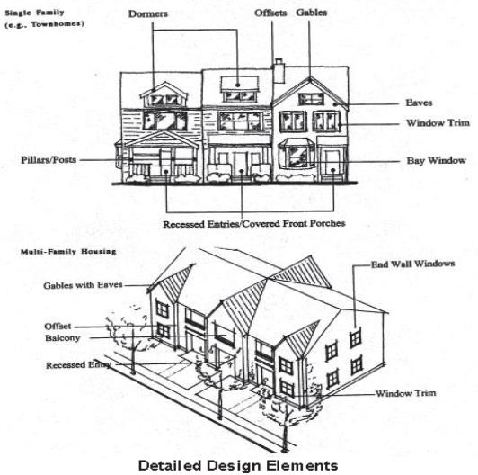
1. Detailed Design Elements. All buildings must provide detailed design along all elevations (front, sides, and rear). A minimum of five architectural features must be provided on the front elevation and a minimum of three architectural features must be provided on the side and rear elevations selected from the following list of features:
a. Dormers.
b. Gables.
c. Recessed entries.
d. Covered porches.
e. Cupolas or towers.
f. Pillars or posts.
g. Eaves with a minimum 12-inch projection.
h. Window trim with a minimum four-inch width.
i. Offsets in building face or roof by a minimum of 16 inches.
j. Bay windows.
k. Balconies.
l. Decorative patterns on exterior finish (e.g., scales/shingles, wainscoting, board and batt, masonry).
[Ord. NS-2487, 2023; Ord. NS-2443, 2022; Ord. NS-2433, 2022; Ord. NS-2423, 2021; Ord. NS-2353, 2019; Ord. NS-2341, 2019; Ord. NS-2271, 2016; Ord. NS-2197, 2013; Ord. NS-2016, 2006; Ord. NS-1877, 2003]