Article VI. Upland Areas of Special Interest Overlay Zone
2.7.700 Upland Areas of Special Interest Overlay Zone.
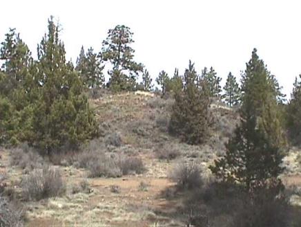
As early as 1975, Areas of Special Interest have been identified as important features in the landscape intended to be preserved as growth occurs. These areas represent potential private and public open space. The upland features consist of scattered rock outcrops, stands of trees, and dominant ridges and faults that are typical of the Central Oregon landscape. These areas contain high points or changes in elevation that break the line of sight so that the area retains a feeling of undeveloped open space.
A. Purpose. Bend is a community that values its natural features of trees and rocks. This section will fulfill the vision of the Bend Comprehensive Plan to retain and conserve the “natural character” of Bend. Natural resources such as rock outcroppings, draws, mature trees, natural vegetation and animal habitat are assets to the community.
The Upland Areas of Special Interest Overlay Zone is intended to protect valuable natural resources within the City of Bend’s Urban Growth Boundary while ensuring reasonable use of the property. This section will establish clear and objective design and development standards to protect these resources and preserve and enhance this vision for Bend’s future livability.
B. Applicability.
1. Affected Property. The procedures and requirements of the Upland Areas of Special Interest Overlay Zone apply to any real property designated as having an ASI as mapped on the Bend Comprehensive Plan Map and the City Zoning Map. These standards shall be in addition to the standards of the underlying zone.
2. Activities Subject to Review. Unless specifically exempted from review as described in subsection (B)(3) of this section, activities subject to review and which require a permit shall include all development on properties described below:
a. Partitioning and subdividing of land.
b. New structural development.
c. Exterior expansion of any building or structure, or increases in impervious surfaces or storage areas.
d. Site modifications including grading, excavation or fill, installation of new utilities, construction of roads, driveways, or paths.
e. Removal of trees or cutting or clearing of any native vegetation within the Upland Area of Special Interest.
3. Exemptions. Activities exempt from this section include:
a. The sale of property.
b. Temporary emergency action necessary for the safety and protection of property or the public.
c. Commercial forest practices regulated by the Oregon Forest Practices Act.
C. ASI Review Process. For all activity subject to the Upland Area of Special Interest Overlay review, the following shall apply:
1. The ASI Review shall be processed as a “Land Use Permit” as defined in BDC Chapter 4.1, Development Review and Procedures. When practicable, the ASI Review shall be processed concurrently with other land use permits.
2. The ASI Review application is subject to the provisions of this chapter.
3. The ASI Review application shall be filed on a form provided by the City and shall be accompanied by a filing fee, drawings and information specified in this chapter.
D. Development Standards. The ASI Boundary is delineated by the outside edge of the boundary line shown on the Bend Comprehensive Plan Map and the City Zoning Map. No development as defined in this chapter must occur within an Upland Area of Special Interest boundary unless expressly permitted by the provisions of this chapter.
The development standards apply to structures, fences, impervious surfaces including streets and driveways except where provided for in this section and landscaping as described in subsection (D)(5) of this section. In addition, no stockpiling of fill materials, parking or storage of equipment or personal property must be placed within an Upland Area of Special Interest.
1. Setbacks. There shall be a 25-foot setback from the ASI boundary for all structures requiring a building permit to provide adequate fire fuel break and to reduce the visual impact to the Area of Special Interest. This additional setback area may be used in addition to the ASI area to calculate any density credit.
The permanent alteration of an Upland Area of Special Interest by grading, excavation or fill, the placement of impervious surfaces, or by the removal of existing vegetation is only permitted in association with the following enumerated uses and subject to the requirements.
2. Streets and Driveways. Public or private streets and driveways may be placed within an Upland Area of Special Interest to access development activities if it is shown that no other practicable method of access exists. If allowed, the applicant shall demonstrate that:
a. No other practicable access to the buildable area exists, or access from an off-site location through the use of easements is not possible;
b. Roads and driveways are designed to be the minimum width necessary and the minimum intrusion into the Upland Area of Special Interest while also allowing safe passage of vehicles and/or pedestrians;
c. The need for future extensions of shared access, access easements, or private streets to access potential new building sites have been considered at the time of this application in order to avoid subsequent encroachments into an Upland Area of Special Interest.
3. Utilities and Drainage Facilities. Public and private utilities or drainage facilities may be placed underground within an Upland Area of Special Interest when it is shown that no other practicable alternative location exists. If allowed, the applicant shall demonstrate that:
a. No other practicable access exists or access from an off-site location through the use of easements is not possible;
b. The corridor necessary to construct utilities shall be the minimum width practicable;
c. Removal of existing trees and native vegetation shall be avoided unless absolutely necessary.
Any permanent alteration of an Upland Area of Special Interest by the construction of public or private streets, driveways, utilities or drainage facilities is subject to the mitigation requirements under subsection (F) of this section.
4. Removal of Vegetation. Removal of existing vegetation from an Upland Area of Special Interest is prohibited, except as indicated below:
a. A tree in danger of falling and thereby posing a hazard to life or property may be removed, following an assessment evaluation from a Qualified Professional. If no hazard will be created, the tree or snag may be required to be left in place within the Upland Area of Special Interest to provide wildlife habitat.
b. Diseased or dying trees that may pose a threat to the health of surrounding vegetation as determined by a Qualified Professional.
c. The removal of noxious weeds and nonnative grasses (e.g., knap weed, toad flax or cheat grass) is encouraged when practicable with minimal disturbance to the ASI.
5. Enhancement of an Upland Area of Special Interest. Planting of additional vegetation within an Upland Area of Special Interest is permitted as indicated below:
a. Plant materials shall be native to Central Oregon and similar to the existing plant species in the vicinity of the ASI.
b. No permanent irrigation shall be installed.
6. Development Credit. When an applicant preserves an Upland Area of Special Interest, the development potential for the preserved area may be transferred to the balance of the parcel for development or applied to the subject property as indicated below:
a. For residential lands where the property owner preserves an Upland Area of Special Interest, the property owner shall receive a density credit equivalent to the area being preserved as determined through the land use permit process.
b. Where the applicant preserves an Upland Area of Special Interest, the property owner may initiate one or more of the activities listed below; provided, that the compensation does not exceed the benefit of the ASI protection as determined through the land use permit process.
•Substitute the preserved ASI as the equivalent required on-site landscaping;
•Reduce the front yard setback up to 50 percent of the standards required for the applicable zone;
•Develop accessory dwelling units on lots abutting an area of special interest.
c. For subdivision development, where the applicant preserves an Upland Area of Special Interest, the property owner may incorporate flexible lot development standards typical of a PUD when the area of special interest occupies more than 20 percent of the subject property.
d. Opportunities for tax benefit in accordance with the provisions of the Deschutes County Tax Assessor.
E. Exceptions and Variances. An exception or variance to the provisions of this code shall apply to property where no further land division is feasible. An exception or variance is permitted only when considered necessary to allow reasonable economic use of the subject property or to provide public benefit.
1. Exceptions.
a. Properties which have existing structures or site development within an ASI on the effective date of the ordinance codified in this chapter, and which do not conform to the standards stated herein, shall be considered nonconforming.
b. For existing platted lots where the location of an Upland Area of Special Interest results in a building area depth for a single-unit dwelling of 25 feet or less or a building envelope of 800 square feet or less, or a commercial building area depth of 100 feet, the front and side yard setbacks may be reduced up to 50 percent of the standard required for the applicable zone.
c. For existing platted lots where the entire lot is located within an ASI, the property may be developed with permitted uses, subject to the applicable land use review, in a manner that will have the least impact to the ASI.
d. The construction of public trails or paths that provide public access into the preserved Upland Areas of Special Interest.
2. Variances. A variance shall only apply to property where strict interpretation of the standards would preclude reasonable use of the land that could be expected to occur in the zone, and that the property owner would be precluded a substantial property right enjoyed by the majority of landowners in the vicinity.
Criteria: No variance request shall be granted unless the applicant can establish:
a. That special conditions exist which are peculiar to the subject property which make conformance to the standards of this chapter impractical.
b. The variance is the minimal deviance from the standards of this chapter needed to accomplish the objective.
c. The varied standard will conform to the purpose and objectives of the Bend Comprehensive Plan and this chapter.
In any case, the granting of a variance shall not adversely affect the potential for public access into an Area of Special Interest, adequate provision for fire protection or the visual integrity of the Area of Special Interest.
A variance to the standards of this chapter shall be processed as a “Land Use Permit” as defined in BDC Chapter 4.1, Development Review and Procedures. The Review Authority may attach conditions to any variance granted to ensure that the variance meets the objectives of the Bend Comprehensive Plan and this chapter.
F. Areas of Special Interest Mitigation Standards. The development activities listed in subsections (B) and (D) of this section may trigger a requirement for mitigation. When a proposed development impacts an Upland Area of Special Interest by grading, excavation, or fill, the placement of impervious surfaces, or by the removal of vegetation, a mitigation plan prepared by a qualified professional shall be submitted to the Review Authority. The mitigation plan shall include the following:
1. The location of the impact, the existing conditions and area size of the resource prior to impact, the location and size of the proposed mitigation area, and a proposed mitigation plan that represents a 1:1 replacement value;
2. All proposed vegetation planted within the mitigation area shall be native to the region and similar to the vegetation removed. Species to be planted in the mitigation area shall replace those impacted by the development activity at a 2:1 ratio;
3. Additional mitigation measures may be required based on the nature of the impact such as:
•Site reclamation.
•Screening of structures, cuts or fills.
•Increased vegetative quantities and/or sizes.
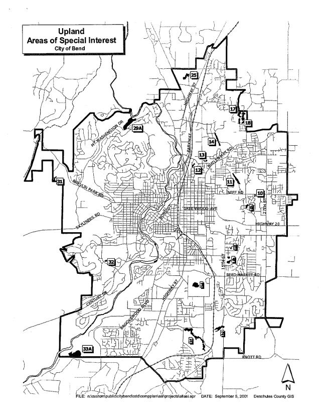
G. Standards for Designating New Upland Areas of Special Interest. Any individual or organization may apply for designating new Upland Areas of Special Interest. Designation of new areas shall be coordinated with the affected property owners. An “Upland Area of Special Interest” designation may be imposed or modified pursuant to an ASI analysis. During January of each “odd numbered” calendar year, individuals may apply to the City for new ASI designations to be added to the Bend Comprehensive Plan and Zoning Maps. The City will process applications received during this time without fee. During the same time period, the City shall review City-owned properties for potential new ASI designations. A new designation shall be processed as a map amendment to both the Bend Comprehensive Plan and Zoning Maps pursuant to the City of Bend Procedures Ordinance and this section.
1. Procedure.
a. The applicant shall file an application for a Bend Comprehensive Plan Map amendment and Zoning Map amendment on a form provided by the City and shall be accompanied by a filing fee, drawings and appropriate information.
b. The Review Authority shall conduct an evaluation. Using the “ASI” Analysis Methodology, the outcome of the analysis must establish that the proposed sites merit resource protection as an “Area of Special Interest” in order to proceed.
2. ASI Analysis Methodology. The City shall evaluate potential Upland Areas of Special Interest using the 1999 Natural Areas Scoring System (NASS) developed by the Bend Urban Land Survey team. The NASS is a numerical ranking which represents the relative values of a natural resource site. The following nine criteria and scoring system are used to determine the total assessment score:
|
Criteria |
Score |
Explanation |
|---|---|---|
|
Existing Site Use |
6 |
Undeveloped |
|
4 |
Minor development |
|
|
2 |
Significant development |
|
|
0 |
Development that substantially reduces open space value |
|
|
Habitat Value |
6 |
Supports a broad diversity of bird and/or animal life |
|
4 |
Supports moderate diversity of bird and/or animal life |
|
|
2 |
Limited habitat value |
|
|
0 |
Almost no habitat value |
|
|
Trees and Vegetation |
6 |
Mature trees, quality riparian vegetation or other significant vegetation |
|
4 |
Some trees, other lower quality vegetation |
|
|
2 |
Little significant vegetation |
|
|
0 |
Almost no vegetation |
|
|
Natural Features |
6 |
Uncommon or outstanding natural features |
|
4 |
Natural features of good quality |
|
|
2 |
Natural features are not distinctive |
|
|
0 |
Almost no natural features |
|
|
Conflict with Adjacent Land Use |
6 |
No conflicts |
|
4 |
Slight conflicts |
|
|
2 |
Moderate conflicts |
|
|
0 |
Severe conflicts |
|
|
Wildlife Linkages |
6 |
Quality connections to other wildlife areas |
|
4 |
Some connections |
|
|
2 |
Minor connections |
|
|
0 |
No connections |
|
|
Scenic Resources |
6 |
Highly attractive scenic resources |
|
4 |
Moderately attractive |
|
|
2 |
Limited scenic value |
|
|
0 |
Unattractive |
|
|
Public Access |
6 |
Potential for high use |
|
4 |
Potential for moderate use |
|
|
2 |
Low potential for use |
|
|
0 |
No potential for use |
|
|
Type of Water Present |
6 |
Has a variety of flows |
|
4 |
Year-round water source of good quality |
|
|
2 |
Seasonal water |
|
|
0 |
No water or low quality water source |
H. Delineation of New Upland Areas of Special Interest. The ASI delineation is a more precise determination of the location of the designated area. The delineation is determined by several factors including but not limited to the topographical contours, the presence of significant trees and an on-site field location conducted by the Review Authority.
1. Topography. The boundary of the designated area will be determined to be at the toe of the slope or slope transition for upland features as illustrated on an adopted map specific to each ASI unless otherwise determined by the Review Authority based on field observation.
2. Significant Trees. The ASI boundary may include significant trees as defined in this code measured at the outer edge of the tree canopy based on aerial photos and field observation.
3. Evaluation Methodology. A potential new site within the “Upland Feature” category would be evaluated using the following method:
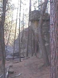
ASI No. 4 on the east side of 15th Street
Upland features are natural areas consisting of geologic features and/or vegetation that provide visual and spatial breaks in the developed landscape.
4. Upland Features.
a. Use the following three criteria:
i. Scenic Resources.
ii. Existing Site Use.
iii. Natural Features.
b. Apply the NASS scoring system for these criteria.
c. The combined score must total a minimum of 10 points.
Proposed new sites in the Upland feature category with a minimum score of 10 points would be subject to a second review using all nine NASS criteria. Under the second review, the site must total a minimum of 20 points to be further considered for adoption as an Upland Area of Special Interest.
[Ord. NS-2462, 2023; Ord. NS-2423, 2021; Ord. NS-2271, 2016; Ord. NS-2016, 2006; Ord. NS-1803, 2001]